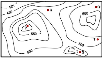
Gate2017 cs Q6

0. A contour line joins locations having the same height above the mean sea level. The following is a contour plot of a geographical region. Contour lines are shown at 25m intervals in this plot. If in a flood, the water level rises to 525m, which of villages P, Q, R, S, T get submerged?

  • Option : C
  • Explanation :
    The given contour is a hill station, the peak point of this hill station is P, it is under a contour of 550. At floods, the water level is 525m. So, the village of R, S and T are under a contour of 500. Therefore, these villages are submerged.
Cancel reply

Your email address will not be published. Required fields are marked *


Cancel reply

Your email address will not be published. Required fields are marked *